Canberra’s Future Transport Network
Canberra’s future is a truly connected network for many diverse journeys, that makes the most of all transport types and creates many possible journeys to varied locations.
To do this, we will target investment to support the efficient movement of people and make good use of limited road space, reduce carbon emissions and drive a compact urban form. This means continuing to invest in public transport, creating streets that are safe and attractive to walk or cycle in, maintaining a reliable orbital road network for private vehicle travel and freight; and improving connections to our region and the rest of Australia.
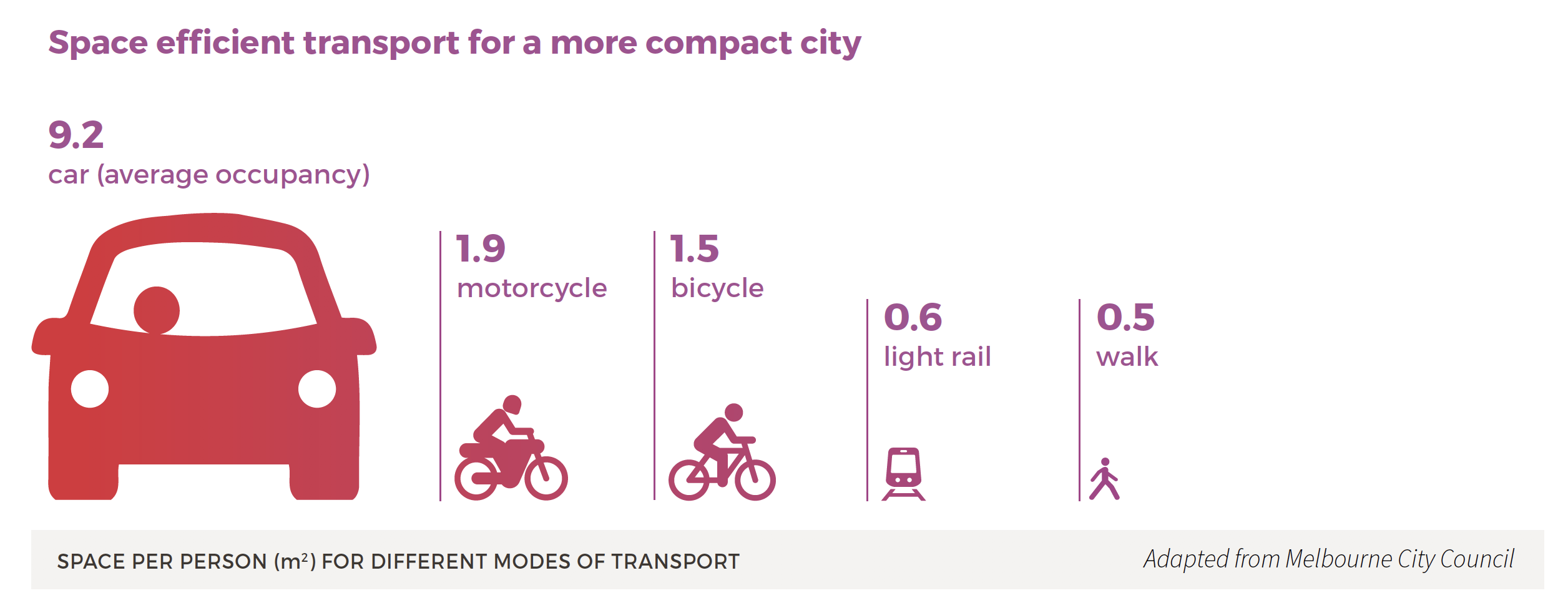
Historically, planning and investment tended to focus on road expansion to support urban growth. Investment in single modal solutions in isolation, will no longer meet our strategic objectives or capacity needs. Public transport, cycling and walking are low emission forms of transport that make highly efficient use of space and support the activation of places. But they cannot meet all trip needs. Canberrans will continue to need to use the car for certain trips and freight will remain important for prosperity.
The 30-minute city is as much about planning as it is about transport. It is a land use planning tool that is about creating mixed use neighbourhoods that allow people to have all their daily needs met – work, education, shopping, health, social or culture within 30-minutes of their home.
To manage growth and meet strategic objectives, our transport network will need to support a shift towards public transport, cycling and walking, while recognising the need for car trips for cross city journeys and freight movement. The transport network will support all trips and all transport types, but to enable more efficient movement, it will focus movement according to location in reflection of the strategic directions set out in the ACT Planning Strategy 2018.
Network structure
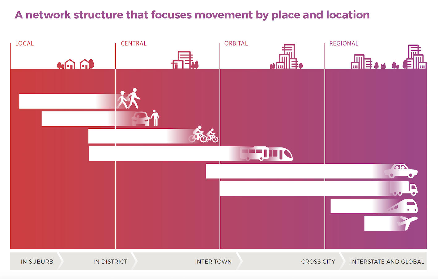
Movement and Place is a key shared concept of the ACT Planning Strategy 2018 and this strategy. Drawing on the Movement and Place concept, Canberra’s transport network will be structured through local, central, orbital and regional links. The combination of central and orbital links will provide the backbone of Canberra’s future transport network. Different links will focus on the most efficient and appropriate movement type for that link and surrounding land uses. This will encourage people to make appropriate transport choices depending on their destination, purpose and time of day. In this way, our network will operate to reduce congestion, reduce emissions and support a more liveable city.
Local links provide for short trips within local areas, focused on walking and cycling. These links will be highly integrated with places for meeting and interacting. They will also be connected into our public transport network to support safe, accessible access. Supporting the core of Canberra’s social fabric, local links are integral to the creation of accessible places for social interaction to enhance quality of life. Canberra’s city centre, town, group and local centres, as well as neighbourhoods, will feature high quality walking environments to support liveability, social connection and vibrancy.
Central links will focus on the efficient movement between centres and urban intensification areas by public transport, walking and cycling. The primary function of the central links is to support the development of centres and urban intensification areas by moving people efficiently between areas that are likely to see more activity in the future.
Orbital links will support trips around and across the city, for private vehicles and freight. These links maintain the private vehicle journey times we all rely on to get around Canberra quickly. Road quality will be enhanced to improve safety and reliability. Intelligent technologies will help proactively manage congestion and provide people with real-time information about their journey and road condition in advance.
The freight network will be based on orbital links and will continue to support national standards for heavy vehicles set out by the National Freight and Supply Chain Strategy 2019 for larger freight vehicles to travel safely and efficiently on our roads.
Regional links will focus on enhancing regional connectivity. This includes rail between Canberra and Sydney, road freight routes for trade connections to inland and coast regions, and air routes that link Canberra to the world.
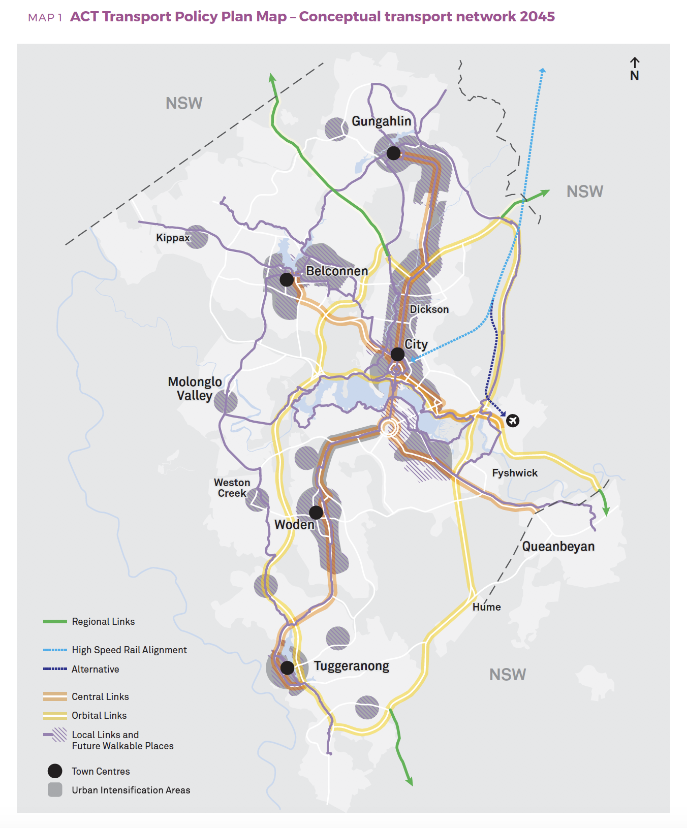
Future network overview
The future network structure supports and reinforces the ACT Planning Strategy’s plan for future land use in Canberra. The following map outlines the conceptual policy framework for Canberra’s future transport network to both respond to the place making priorities and shape the city’s future urban form.